
Introduction
When transporting standard cargo, logistics teams can often rely on established transportation routes. However, moving project cargo is a completely different challenge. Large machinery, oversized equipment, industrial components, and heavy structures may not fit through conventional routes. A road that is suitable for a standard truck may be impossible for a heavy-haul vehicle carrying an oversized load. This is why a project cargo route survey is an essential part of planning complex cargo movements. A route survey examines the complete transportation path from the cargo’s origin to its final destination. It identifies potential obstacles, evaluates road and infrastructure conditions, and helps logistics teams determine whether specialized transportation can safely complete the journey. In this guide, we explore why project cargo route surveys matter and how they support safer and more efficient project cargo logistics.
What Is a Project Cargo Route Survey?
A project cargo route survey is a detailed assessment of the proposed transportation route for oversized, heavy, or specialized cargo. The objective is to identify anything that could affect the movement of the cargo. The survey may examine:- Road widths
- Bridge capacities
- Turning radii
- Height restrictions
- Road gradients
- Overhead cables
- Tunnels
- Traffic conditions
- Railway crossings
- Roundabouts
- Sharp bends
- Road surfaces
- Construction zones
- Access to the final destination
Why Are Route Surveys Important for Project Cargo?
A large shipment can travel thousands of kilometers internationally, but the success of the journey may depend on a single narrow bridge, low overhead cable, or difficult turn. For example, a shipment may successfully arrive at a destination port but then discover that the final road to the project site cannot accommodate the transport vehicle. This can create:- Delays
- Additional transportation costs
- Storage requirements
- Route changes
- Permit complications
- Equipment repositioning
- Project schedule disruptions
1. Understanding Cargo Dimensions
Before surveying the route, logistics teams need accurate information about the cargo. Important details may include:- Length
- Width
- Height
- Weight
- Center of gravity
- Loading configuration
- Transport trailer dimensions
2. Evaluating Road Width
Oversized cargo may require significantly more road space than standard vehicles. A route survey should determine whether the roads are wide enough for:- The transport vehicle
- The cargo
- Escort vehicles
- Oncoming traffic
- Safe maneuvering
- Temporary traffic control
- Road closures
- Removal of roadside obstacles
- Alternative routing
3. Checking Bridge Capacity
Bridges are one of the most important considerations in project cargo route planning. A heavy transport vehicle can place significant loads on bridges. The route survey may therefore examine:- Bridge weight limits
- Structural condition
- Load distribution
- Vehicle axle configuration
- Bridge clearance
- Restrictions for heavy vehicles
4. Measuring Overhead Clearances
Height restrictions can create serious challenges for oversized cargo. Potential obstacles may include:- Bridges
- Tunnels
- Power lines
- Communication cables
- Traffic signals
- Road signs
- Building structures
5. Analyzing Turning Radii
Large transport vehicles require more space to turn than standard trucks. Sharp corners and narrow intersections may become difficult or impossible to navigate. A route survey should identify:- Sharp turns
- Roundabouts
- Intersections
- U-turns
- Narrow junctions
6. Evaluating Road Gradients
Steep slopes can affect heavy and oversized transportation. The route survey may examine:- Uphill gradients
- Downhill gradients
- Road surface conditions
- Vehicle braking requirements
- Available traction
7. Checking Railway Crossings
Railway crossings can present additional challenges for project cargo transportation. The logistics team may need to consider:- Clearance
- Crossing angle
- Road surface
- Train schedules
- Traffic management
- Vehicle speed
8. Identifying Roadside Obstacles
A route survey should not only examine the road itself. The surrounding environment can also affect transportation. Potential obstacles may include:- Trees
- Streetlights
- Traffic signs
- Utility poles
- Buildings
- Walls
- Road barriers
9. Assessing Traffic Conditions
Heavy and oversized cargo can affect normal traffic flow. The route survey may consider:- Traffic volume
- Peak traffic periods
- Urban congestion
- Road closures
- Construction activity
10. Reviewing Road Conditions
Road quality is another important factor. The route may include:- Paved roads
- Gravel roads
- Unpaved sections
- Damaged surfaces
- Temporary roads
- Construction zones
11. Evaluating the Final Mile
The final part of the journey can often be the most challenging. A shipment may travel smoothly from the manufacturing facility to the destination port, but the final road to the project site may be narrow, remote, or difficult to access. The route survey should therefore include the entire journey. This means assessing: Origin → Inland Route → Port → Destination Port → Inland Route → Project Site The final few kilometers should receive the same attention as the international transportation route. This is a critical part of successful project cargo delivery.12. Planning Alternative Routes
A strong project cargo route survey should identify alternative options whenever possible. If the primary route becomes unavailable because of:- Road closures
- Weather
- Construction
- Accidents
- Unexpected obstacles
13. Coordinating With Local Authorities
Oversized and heavy cargo movements may require coordination with local authorities. Depending on the route, this may involve:- Transportation authorities
- Police
- Municipal authorities
- Road agencies
- Utility companies
- Special permits
- Traffic control
- Road closures
- Escort vehicles
- Utility adjustments
14. Planning for Utility Lines and Cables
Overhead utility infrastructure can create major challenges for oversized cargo. The route survey should identify:- Power lines
- Telephone cables
- Communication infrastructure
- Low-hanging wires
15. Considering Weather and Seasonal Conditions
A route that is suitable during one season may become difficult during another. Weather conditions can affect:- Road surfaces
- Flood-prone areas
- Mountain routes
- Visibility
- Traffic conditions
16. Using Technology in Route Surveys
Modern technology can support the route survey process. Depending on the project, logistics teams may use:- Digital mapping
- Satellite imagery
- GPS data
- 3D route modeling
- Drone surveys
- Vehicle tracking systems
17. Turning Survey Findings Into a Transport Plan
A route survey is valuable only when its findings are incorporated into the actual logistics plan. The survey results may influence:- Trailer selection
- Transport vehicle configuration
- Travel schedule
- Route selection
- Escort requirements
- Permit applications
- Traffic management
- Loading arrangements
18. Route Surveys for Multimodal Project Cargo
Many project cargo shipments involve multiple transportation modes. For example: Factory → Truck → Port → Vessel → Destination Port → Truck → Project Site A route survey may therefore be required for both the origin and destination inland routes. The logistics team should consider how the cargo will move between each transportation stage. This helps create a more connected project cargo logistics plan.Benefits of a Professional Project Cargo Route Survey
A detailed route survey can help businesses achieve:Better Route Planning
Potential obstacles can be identified before transportation begins.Improved Safety
The transportation team can better understand route conditions.Reduced Delays
Problems can be addressed before the shipment is on the road.Better Permit Planning
Required approvals can be identified earlier.Improved Equipment Selection
Transport vehicles can be selected based on actual route conditions.Better Cost Control
Unexpected route changes and emergency arrangements may be reduced.Improved Project Scheduling
The transportation timeline can be planned more accurately.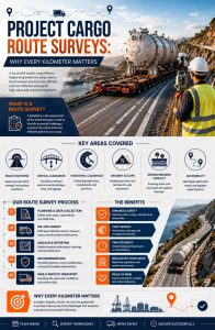
How DDU Express Can Support Project Cargo Transportation
Complex project cargo logistics requires careful planning at every stage of the journey. DDU Express can support businesses with logistics solutions for specialized cargo movements, helping coordinate transportation requirements for complex international shipments. For oversized and heavy cargo, route planning is an important part of preparing the shipment for transportation. By considering cargo dimensions, road conditions, infrastructure, permits, and final-site access, logistics teams can create a more coordinated approach to project cargo transportation. An experienced logistics partner can help businesses navigate the complexities involved in moving specialized cargo across international supply chains.Final Thoughts
When moving project cargo, every kilometer matters. A route that looks suitable on a map may present significant challenges once the actual dimensions and weight of the cargo are considered. From bridge capacities and overhead clearances to turning radii, road conditions, utility infrastructure, and final-mile access, a detailed project cargo route survey helps logistics teams identify potential problems before transportation begins. For complex cargo movements, route planning is not simply about finding the shortest path. It is about finding a route that is safe, practical, legally permitted, and suitable for the cargo. By conducting thorough route assessments and incorporating the findings into the overall logistics plan, businesses can improve coordination and reduce unexpected challenges throughout the transportation journey.Planning an oversized or heavy project cargo shipment?
Partner with DDU Express for coordinated project cargo logistics solutions designed to support complex international cargo movements from origin to final destination.
Weiworld is an experienced logistics and shipping professional with more than 20 years of industry experience, with extensive knowledge of international shipping, freight forwarding, cargo movement, and logistics operations.
Over the course of his career, he has developed deep practical expertise in Middle East logistics and operations, including shipping processes, international cargo transportation, customs-related procedures, and supply chain coordination.
At DDU Express, Weiworld shares practical insights and industry knowledge to help businesses better understand international shipping, freight forwarding, DDP services, cargo transportation, and logistics solutions across the Middle East and global markets.
His extensive industry experience provides valuable perspective for businesses looking to simplify international shipping and make informed decisions when moving cargo between countries.